


EVEREST REGION

Reach the highest point on earth or choose to live out your dream by standing at the foot of Mt. Everest (8,848 m).The Everest region in Nepal is more than just trekking, it is a milestone in anyone€™s life; and some have even described the experience as a journey close to Nirvana. Located in the northeast province of Nepal, this is a colony to dramatic glaciers, deep settlements, several majestic mountains.
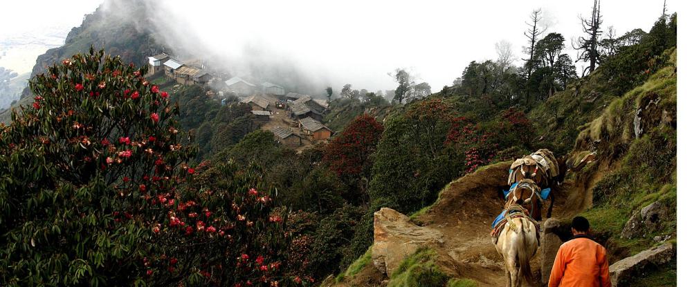
Passing through legendary Sherpa villages, the trek is a mix of a deeply cultural and spiritual experience in addition to the physical one. Buddhist lamas, monks and nuns led by Rinpoches (reincarnate lamas) serve the predominantly Sherpa communities from gompas (monasteries).
The journey to Everest or Everest Base Camp, begins from Lukla, if you are taking a direct flight from the capital. However, for die-hard lovers of trekking, there is an another switchback starting from Jiri through the mid-hills of Solu; ethnically diverse and flora-rich.
Taking a flight is a time-saver, while trekking from Jiri gives you the opportunity to take in each tiny detail of the trek, with extra time to to meet the charming people and see the rich flora and fauna on the trail.
The option from Jiri will roughly take 10 days to reach the famous Sherpa village, Namche Bazaar (3,500m). The Sagarmatha National Park in the Khumbu is one of the few places on earth with the rarest bio-diversity and the highest and youngest mountain system in the world.
For those with sufficient time, a 10-12 day trek through Solu to the Khumbu and the Sagarmatha National Park is an excellent itinerary both in terms of acclimatization and to experience the changing customs, traditions, and lifestyles as you pass through lower altitude settlements to those in the higher altitudes.A part of the Himalayan ecological zone, the park was added to the list of UNESCO Natural World Heritage Sites in 1979. The park contains three of the world’s seven highest mountains Sagarmatha or Mt. Everest, Lhotse, and Cho Oyu and is also home to several other prominent peaks most of which are above 6,000 meters.
Climbers and trekkers continue to trek to Everest Base Camp and not surprisingly the “Roof of the World” continues to be the scene of some of mountaineering’s most significant accomplishments and a favored haven for alpine enthusiasts.
The Everest region has been valued as the key to evolutionary history of the Earth, and is also a habitat for some rare and endangered species like snow leopard, red panda, Himalayan black bear, musk deer and Himalayan wolves.
ANNAPURNA REGION

The legendary Annapurna region is the most diverse and popular trekking area in Nepal. From the full three-week Annapurna Circuit, which stretches into the historic Mustang region to short three-day treks, there’s a trek suitable for everyone here.As the name suggests, the centre piece of this part of Nepal is the range of mountains that includes Annapurna I, the first of the 8,000 m peaks to be climbed. Also included in this region is another 8,000 m giant, Dhaulagiri, which is located west of Annapurna I.
Between these two mountains lies the valley of the Kali-Gandaki River, the deepest gorge in the world.
Views of lush, fertile farmland and undisturbed natural forest, snow covered mountains, and encounters with a mixture of many ethnic communities, all add up to a diverse range of experiences that make this area one of the most satisfying trekking destinations in Nepal.The fact that the Annapurna chain of mountains lies inland causes a large chunk of land to fall in the rain shadow area.
Hence these parts are considerably drier than the southern slopes of the mountains. This leads to unusually diverse landscapes and the possibility of trekking during the monsoon.
GORKHA

The historic birthplace of Prithvi Narayan Shah, who unified the kingdoms of Nepal in 1769 it maintains much of its centuries old charm with the main Durbar Palace as the central attraction. Trekkers often depart from here on the great Manaslu circuit while also enjoying this classic and much loved cultural town.Gorkha is the foundation of Nepal. It is the home to the bravest-of-the-brave troops in the world, Gurkha. From the Gorkha only, the vision of present-day Nepal was sketched by the first king of the modern Nepal. Before that, Nepal was divided into small kingdoms until when Prithvi Narayan Shah, the first king of (modern) Nepal had the vision to unite small kingdoms into a singular strength to build a wall against the rising force from the East, East India Company.
Gorkha holds the history of the country. The Gorkha Durbar (Palace), built on the hilltop above the market below, is the finest example of architectural and war-strategy of the past. From the palace, one can see the 360-degree view of the Gorkha village, which makes the palace as a vantage point, for now, but it was a strategy to protect the royal families from the invading armies, in the past.Gorkha is mostly populated by the Gurung tribesmen, who have earned enough praise in the both World Wars, including Victoria Cross. However, despite their fierce attitude in the battlefield, they are friendly people with a tradition of genuine hospitality. Around Gorkha, one may hike to a jungle and enjoy watching hunters collecting wild honey. Honey Hunters of Nepal, a documentary from Diane Summers and Eric Valli did their famous art of work, photography and video, in Gorkha, only.
JANAKPUR

Stroll through the ancient Mithila city to experience the Terai culture of southern Nepal and visit the Ram Janaki Temple in the center of the city that draws allusions to the famous Hindu epic Ramayana.The city that has been mentioned in Ramanayana as birthplace of Sita, Ram€™s consort. As Ram is believed to be the incarnation of Lord Vishnu, Sita is believed to be the incarnation of Goddess Lakshmi as per the great Hindu epic Ramayan.
It is also believed that it was in Janakpur that Lord Ram and Sita met and were married to each other. Janakpur is also on the holy route of Parikrama (holy circle) carried out by Hindus as a form of worship in Ayodhya, Kashi and Brij in India as well.
Another important religious site nearby is Dhanushadham, its reference again dating back to the Ramayan era. It is believed to be the place where the broken remains of the divine Shiva bow fell after Ram broke it to obtain Sita’s hand in marriage.
A fossilized fragment of the broken piece is still believed to present here. Dhanusha offers: religious sightseeing, lush surroundings of trees and groves, semi-rural charm of the Terai suburbs, and the colorful Maithali art and culture.
PeopleDiverse ethnic groups live in the district of Dhanusha. Yadavs, Teli, Brahmins, Kyastha, Tharu, Musahar, Rajput, and Chhetri are the main inhabitants of these villages. Most are farmers by occupation. The whole region is also considered the center of Maithali culture, therefore Maithali art and culture is predominant in this area.
Getting There
Dhanusadham is in Dhanusha district and Janakpur zone.
Janakpur is approximately 390 km and 10-hour drive from Kathmandu. Buses to district headquarter Janakpur city leave from Central Bus Station, Gongabu in Kathmandu. One can also take a 40-minute flight to Janakpur city from Kathmandu. Dhanushadham which is 18 km is an hour-drive from Janakpur. Public transportation services are available to Dhanushadham from the city area.
Tourist Services
Luxury hotels to budget accommodation and food facilities are available in Janakpur city. Dharamshalas (accommodation for pilgrims) are also available. Food is delicious with Indian touch. Varieties of sweets and vegetarian specialties are available. Other tourist facilities are also available in Janakpur city.
DOLPO REGION

Trek through the hidden valleys of Dolpa, visit the ancient Shey Gompa (The Crystal Monastery), touch the icy waters of Phoksundo Lake, see yak caravans cross high-Himalayan passes, visit some of the highest settlments on earth like the Dho-Tarap valley; Dolpa will never cease to amaze you.Dolpa or Dolpo was popularized by the film €œCaravan€ which showcases the extraordinary untouched beauty of the region.
It is remote and fascinating, confined by the Dhaulagiri range in the south and east, the mountains Sisne and Kanjiroba in the west and Tibet towards the north. Lake Phoksundo with its turquoise waters is the major attraction in Dolpa.
The people of Dolpa generally settle at altitudes of 3,660 m to 4,070 m and these are probably one of the highest settlements in the world. There are 130 gompas in Dolpa which speaks volumes for the religious nature of its inhabitants.
The trek is enlivened by the sight of yak caravans that even today travel long distances through difficult terrain to barter goods.
Closely linked with Tibet, the people speak Tibetan, have strong Mongoloid features, maintain their Tibetan culture with monasteries that follow closely the Buddhism of Tibet.The proximity with Tibet has ensured that little has changed since their forefathers crossed the border into Nepal. This trek is an opportunity to meet people who follow a lifestyle that goes back centuries.
These unexplored, high altitude valleys were not opened until 1989. Isolated by the difficult topography, the people in this region have preserved their lifestyle, remaining almost untouched by the trappings of modern society.
Dolpa falls among Restricted Areas. Therefore, trekkers require Trekking Permit from the Department of Immigration in addition to the TIMS card to trek to this region. Trekkers should be physically fit as there are long and strenuous stretches en route.
ILAM

A brisk walk in a tea garden, tranquil picnic and sightseeing stops, short treks along gentle slopes, or a trudge into the nearby woods €“ all this and more is offered by Ilam.An excellent getaway from city life, Ilam, famous for its tea, is a small hill town with pristine landscapes of sloped tea gardens, mountain streams, dense natural forests, holy sites and a unique culture. Using Ilam Bazaar as a base you can take excursions for a day or more.
While the subtropical climate of Ilam ensures good weather throughout the year, the best time to visit Ilam is between October-December or from April-February.
Ilam district is bordered by Panchthar in the north, Jhapa in the south, West Bengal (India) in the east and Morang and Dhankuta districts in the west. It lies to the south of the Mahabharat range and west of the Shinghalila range.
Elevations in Ilam district range between 140 m to 3,636 m above sea level. Ilam is sometimes called Charkhol (area of four rivers) because of the four main rivers – the Jogmai, Puwamai, Mai, and Deaumai in the district.
Ilam is one of the richest districts in Nepal in terms of its cultural diversity, natural landscape, and flourishing cash crops sector. Potato, cardamom, ginger, red round chilly, milk, and broom grass are the major cash crops. Visitors also go to Ilam for botanical and anthropological research.The main ethnic groups living in Ilam are the Brahmins and Chhetris. Lepcha is also the predominant ethnic group in this region. A Lepcha museum is at an initial stage in Antu and is in the process of being extended.
Ilam reflects rich social and cultural heritages of people living in harmony. Other major ethnic groups living in Ilam include Magars, Gurungs, Rais, Limbus, and Sherpas. Most parts of Ilam are hilly regions with farmers as main inhabitants along with some businessmen, officials and government employees.
KATHMANDU VALLEY

Discover ancient temples and myths in the valley of gods where Hinduism and Buddhism meet.Smell and eat traditional Newari food cooked on wood ovens while you are strolling through the small little alleys around the €œdurbar squares€ in one of the ancient king cities of the Kathmandu Valley; Bhaktapur, Patan or Kathmandu.
Buy handicrafs from artisans that still work according to centuries-old traditions. Or try if you are talented yourself in one of the many workshops that are available
Watch how the people of the valley still use their temples to practice rituals that have been passed from generation to generation. Discover the temples of the valley, learn more about the rituals of the people of Nepal.
Visit 7 monuments of UNESCO World Heritage Site Kathmandu in 48 hours.
There is a famous folk story that narrates the establishment of the Kathmandu Valley. Long ago, during the Pleistocene era, Kathmandu Valley was merely a lake €“ a beautiful exhibition of aquatic flora and fauna. Around the same era, when Manjushree, a holy Buddhist Saint from Tibet, saw a beautiful lotus flower floating in the center of the lake, boundless admiration started to flame inside his heart, which evoked his devotion to hold and worship the flower.
He, then, cut the Chobar Hill; that €˜cut€™ turned into a deep gorge, letting lake water drain out, and leaving a fertile, and pious land for human settlement. Later the settlement became a well-known terminal for diverse individuals; for devotees (both Hindus and Buddhists), Tibetan and Indian merchants, artisans, emperors, explorers, historians, hippies, according to the respective eras, and €“ now – for tourists from all around the world.
The Kathmandu Valley has always been a melting pot for various cultures, religions, and arts and crafts. The Gopala and Kirat dynasties ruled at the earliest periods, followed by the Licchavi (300-879 AD), who, correspondingly, decorated the city with a passion, traditional art, and religious belief.For such reasons, till this date one can experience the authenticity of the valley, its cultural and religious harmony; the varieties of temples of Hinduism and Buddhism that are standing next to each other for centuries, diverse ethnicities, colorful festivals, and celebration, but just within a walking distance, which is, perhaps, the most beautiful highlight of the city.
The Kathmandu Valley envelops three glorious cities – Kathmandu, Patan, and Bhaktapur, which were once independent states ruled by the Malla kings, who ruled the cities from the 12th to the 18th centuries and decorated their individual kingdom with exotic craftsmanship and palaces. Back then, the mighty Mongol rulers would import craftsmen from the Kathmandu Valley to decorate their empire.
That is to say, the famous Pagoda architecture is a gift from the Kathmandu Valley to the China. Now the Kathmandu Valley is home to seven sites which make the valley a UNESCO Cultural World Heritage Site, and also home to hundreds of other exquisite monuments, sculptures, artistic temples and magnificent art €“ reminders of the golden era in Nepal€™s architecture.
TANSEN PALPA

Get charmed by one of the “off-the-beaten-track” destinations in Nepal, the ancient hill town of Tansen. Walk its cobbled bazaar to find a perfect Dhaka topi for yourself. Traverse around Shreenagar Hills, do a day hike to the Rani Mahal on the banks of the Kali Gandaki River or go backpacking along the river trail to find enchanting new routes.Midway between the Indian border and Pokhara, Tansen’s old artistic Newari houses, and cobbled streets, are waiting to be discovered. Palpa was the seat of the Sen kingdom that ruled over this region from 16th century for almost 300 years.
A picturesque hill town lying on the lap of the Shreenagar Hills, Tansen is the headquarters of Palpa district and the hub of the mid west culture of Nepal. The district varies from 250 to 2,000 m in elevation.
The town has houses strongly influenced by traditional Newari architecture. The name “Tansen” has its origin in the Magar language, meaning “northern settlement.” Palpa with its diverse culture and religion falls in the twelve Magar regions of West Nepal.
Tansen can be visited at any time of the year. While the climate of Palpa varies from tropical to moderate, Tansen is moderate to warm with temperatures between 28 degree Celsius maximum during summer and 8 degree Celsius minimum in the winter. The months of June and July have maximum rain.
PeopleThe percentage of the Magar and the Newar population in the district is high. Other inhabitants of Palpa are the Brahmin, Chhetri, Bhojpuri, Tharu, Gurung, Tamang, and Limbu.
Newars, originally from the Kathmandu valley, followed opportunities of trade and craft and migrated to different parts of Nepal. In Tansen they found an important crossroad of trading routes and administrative headquarters.
Though today’s migration movement due to urbanization and decrease in agriculture brings people from all ethnic groups to Tansen, the Newari people still make up a high percentage of the population in the core area. There are also predominant Magar settlements in some parts of Palpa district. The Magars are assumed to be the first settlers in this area.
Getting There
Tansen is in Palpa district, Lumbini zone.
There are regular buses from Kathmandu to Tansen – 296 km from Kathmandu via Butwal and about 324 km from Kathmandu via Pokhara. You can take a daily-scheduled flight from Kathmandu to Pokhara or Bhairahawa. Tansen is conveniently near Lumbini, the birthplace of Lord Buddha, and the popular tourist destination of Pokhara. It is about 3-4 hours drive from either of these cities.
Tourist Services
There are a number of good to moderate hotels and lodges in Tansen to suit every budget and need. The hotels and lodges are clean and the staff hospitable. The modern restaurants serve excellent Nepali meals and some even serve continental cuisine.
TEHRATHUM SANKHUWASABHA
Follow the rhododendron trail of Nepal next spring, trekking through hills of colorful rhododendron along Tehrathum and Sankhuwasabha districts. This is an area of mixed pastures, stunning mountain views, beautiful sunrise and sunset, and friendly Limbu people. Offering excellent respite from city life, the diverse landscape includes terraced fields as well as the Terai plains covered with different types of vegetation.Basantapur (2,200 m) in Tehrathum also hosts trekkers on the way to Taplejung and Mt. Kanchenjunga. The little Basantapur Bazaar is set up in an enchanting surrounding of mountains and greenery.
The weather here is cool and temperate most times of the year, making Basantapur ideal to visit anytime. The best times to visit are autumn and spring, between October-December or from February-April. Summers are pleasant with temperatures ranging from 10 to 20 degree Celsius, while winters mild.
Tin Jure
From Tin Jure Danda (3,066 m) (ridge) one can see magnificent views of sunrise and sunset, and majestic view of the mountains. Thirty-four varieties of rhododendron are found here. Tin Jure Danda is about a half hour away from Basantapur Bazaar.
Tinjure Milke Jaljale Trail, also known as the Rhododendron Trail, spreads across Taplejung, Terathum and Sankhuwasabha districts. Hille, north of Dharan, is a good place to start out. Alternately, you can start from Phidim at the end of a newly completed dry season dirt road that traverses Ilam’s young tea estates.
Heading northeast out of Hille, the trail climbs gradually through settlements of recent migrants from the northern Olangchung region, trans-Himalayan yak drivers who live for months on tsampa (roasted barley flour), dried yak meat, and cheese.
Gupha Pokhari is a serene lake set on a ridge looking east at the Kanchenjunga massif and west at Makalu and the Khumbu Himal (mountain). From here, a shorter trek follows the Milke Danda ridge due north, climbing to 4,700 m into the Jaljale Himal, a remote area spotted with lakes and inhabited by mountain peoples from Tibet.
You can then descend east to the Mewa Khola (stream) and continue to Taplejung’s airfield and further to the Kanchenjunga Conservation Area.
Milke
On the way to Taplejung is another popular rhododendron forest known by the name of Milke Danda (2,905 m). Milke Danda provides a closer view of the Kanchenjunga and Kumbhakarna mountains and offers beautiful sunrise and sunset surprises when weather is clear. It is on the trekking trail between Taplejung and Basantapur Bazaar.
PattekPattek Danda (2,500 m) is equally beautiful for sunrise, sunset and also offers a wide view of the Himalayas including Mt. Everest and Mt. Kanchanjungha. Pattek Danda is ideal for short treks and is also a good area for picnics. There is a popular Goddess Kali temple 2-hour walk west from Basantapur Bazaar. Pattek Danda, about 3 km from Basantapur can also be reached via Chitre that is 15-minute drive away. From here Pattek Dandais a 30-minute trek.
Gupha Pokhari
It is a natural pond that lies on the trekking trail to Taplejung from Basantapur. Picturesque views of mountains, sunrise and sunset can be seen from here. This Pokhari (pond) is culturally significant and is also a good resting place for trekkers to Taplejung
Marg Pokhari
Marg Pokhari (2,600 m) is another natural pond on the lap of the hills. The pond holds religious value and scenic beauty. The pond has contributed to keep the surroundings green. The Marg Pokhari watershed area has a dense forest that habitats popular species of rhododendron and precious plants. Marg Pokhari is on the way to Basantapur from Sindhuwa, which is 5 km from Basantapur Bazaar.
Panchakanya Pokhari
Panchakanya Pokhari is another popular tourist site. Also known as Chhathar Pokhari, Panchakanya Pokhari is approximately 2 hours walk further down from Sukrabare Bazaar. Among the many ponds here, the largest pond in the area is Panchakanya.
A fair known as Sukrabare Bazaar (Sukrabar is Friday in Nepali) is held every Friday in Hammarjung VDC, showcasing the mixed culture of settlements. Majority of the inhabitants here are Limbu. Thus, it is an ideal place and time to experience the rich Limbu culture. The village is popular for homespun cloth called khadi (cotton). The village can be reached via Sindhuwa Bazaar, another popular area of Basantapur.
TAPLEJUNG
Trek through Taplejung in the Kanchenjung region to see towering Himalayan peaks including Mt. Kanchenjunga (8,586 m), the third highest peak in the world, amid lush rhododendron forests.Opt for the sacred Pathibhara trail and get a Darshan of the wish-fulfilling Goddess. Or search deep into the valleys to see cultural treasures in the mountain settlements and ancient routes.
This is one of the most beautiful areas in the country in the far-eastern Nepal borders with India in the east and the Tibetan Autonomous Region of China in the north. Alpine grasslands, rocky outcrops, dense temperate, sub-tropical forests, and low river valleys make up the area.
Nearby is the Tinjure Milke Jaljale ridge that forms border between Taplejung, Tehrathum and Sankhuwasabha districts. This is an area well known for its bio-diversity including the world’s largest natural rhododendron forest with the highest number of rhododendron species in the world.
Ancient Gompas
The rich cultural heritage of Taplejung is reflected in the Buddhist gompas (monasteries) such as the 400-year old Diki Chhyoling Gompa of Olangchungola which has a life size statue of Avalokiteshwara. A butter lamp at the altar has been burning here uninterrupted since the construction of the gompa. The waters of a small stream outside the gompa continuously spin twelve prayer wheels with the prayer “Om Mane Padme Hum” inscribed on them.
People
The predominant people in the Kanchenjunga region are the Limbus, with the higher regions inhabited by people of Tibeto-Mongoloid ancestry. Tibetans, Sherpas, Rais, Gurungs, Magars, Newars, Sunwars, and Tamangs also live in this area, while the area also offers cultural diversity of Chhetris and Brahmins.
Cardamom farming, agriculture, animal husbandry, and tourism are the major means of livelihood for the people here. The Sherpa people, who arrived from Tibet more than four hundred years ago, live at higher altitudes. The Sherpas of this region have distinct culture and tradition – quite different from the Sherpas who live in the Solukhumbu district in the Sagarmatha region.
Getting ThereKanchenjunga region falls in Taplejung district of Mechi zone.
Taplejung is connected to the rest of Nepal by the 227-km Char Aali-Ilam-Phidim-Taplejung road. There is an air link with Kathmandu and Biratnagar from the STOL airstrip at Suketar. You can also take a bus from Dharan to Dhankuta – Basantapur – Hile and trek from there. In the dry season, bus services are available from Birtamod, Jhapa in East Nepal and from Phidim in Panchthar district. Often an overnight stay is required; otherwise, it is a full day’s journey.
Tourist Services
Tourist facilities are available in Phungling Bazaar and Suketar. While trekking, accommodation facilities have to be arranged along the way. Lodges, teashops and campsites are available en route to Kanchenjunga and Pathibhara.
Basic tourist facilities for accommodation and food are available in the area. Private and community-owned campsites are also available. Lodges and home-stays provide local cultural experience.
RARA NATIONAL PARK

Sojourn to the Rara region through thick pine and juniper forests and camp next to the sparkling Rara Lake at 2,990 m, walled by green hills on all sides. Boat in the clear waters, hike to nearby hills for nearer views of the mountains and lake, meet the charming local people, or just take a walk around the lake watching out for a wild flower or a rare bird on the way.
The park is surrounded by alpine coniferous vegetation and offers a representative sample of the region’s flora and fauna. More than 500 different kinds of flowers, 20 different species of mammals and 214 species of birds can be observed at Rara National Park. As for water life in the lake, the snow trout is the fish variety recorded so far.
The rich vegetation of the park is home to the endangered red panda, musk deer, Himalayan black bear, leopard, jackal, Himalayan tahr, yellow-throated martin, wild dog, wild boar, common langur, rhesus macaque and common otter. During winter the park abounds in bird varieties like coots, great-crested grebe, black-necked grebe, red crested pochard, mallard, common teal, merganser and gulls. Migrant water fowls and gallinaceous birds can also be seen during certain seasons.
Rara in the far northwestern part of Nepal is the smallest national park, while the Rara Lake is the biggest lake in the country. The lake is 167 m deep at some places, and drains into the rivers Mugu Karnali via Nijar Khola. Chuchemara Hill at 4,087 m is the best vantage point to get the magnificent views of the deep blue clear lake and the forested hillsides as well as the snow capped peaks around it.
The easiest means to reach Rara is to take a flight from Nepalgunj to Jumla, from where your destination is 2-3 days walk away. You could also start this refreshing trek in the hilly village of Jumla where apple orchards stretch out over the hills.
The trek leads through remote countryside toward the Tibetan border. A journey into the Jumla region and the beautiful Rara Lake, is probably one of the most rewarding and fascinating treks in all the Himalayan range given its un-spoilt splendor of nature.
The best time to visit the park is autumn, spring and summer. As a well-loved tourist region, tourist services and infrastructure have developed over the years. However, for best experience it is still most advisable to be self sufficient if traveling alone. Lake Rara is also a popular pilgrimage site for Nepalis.
MANASLU CONSERVATION AREA

A wonderfully pristine trekking circuit which allows you to circle around Mt. Manaslu, the world’s eighth highest peak. Visit untrampled trails through rural Nepal with epic views that have to be seen in person to be truly experienced.
Manaslu (8,152m) is an opportunity to enjoy quiet time trekking in pure bliss away from the noisy modern world.
The trek on an ancient trail along which you enjoy authentic Nepali culture and hospitality, promises breathtaking views of Mt. Manaslu and its Himalayan peaks counterparts always on the background. Be prepared to witness the ancient culture and almost medieval lifestyle of the people as you trek up northwards.
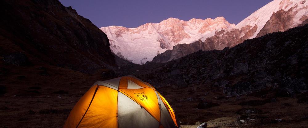
Modernization and commercialization have not touched the purity of the environment yet, so your trek to Manaslu will be a time-travel experience. Teahouses are on the trail for night stay. The other option is to camp under the starts.
Internet access and charging of phone and other electronic equipments, are possible at the tea houses along the trail. The trek offers ample opportunities to take great pictures. Therefore, don’t forget to carry a good camera!
Manaslu shares much of its culture and history with its neighboring territory, Tibet. Buddhism is major religion, as one can observe Buddhist monasteries, architecture, and tradition all the way.
The region, which was officially opened for visitors from abroad only in 1991, falls in the Restricted Areas and tourists must acquire Trekking Permit from the Department of Immigration in addition to the TIMS card for visit for visit to this region.
BARDIYA NATIONAL PARK

Ride through the silent jungle catching wildlife by surprise in the largest national park of Nepal in Bardiya or take nature walk under the guidance of expert naturalists with years of experience.
Combine it with white-water rafting in the longest river of Nepal, Karnali, where you could even spot dolphins or gharial on a lucky day. And meet the charming Rana Tharu and Dangora people of southern Nepal to know more about their culture.
A trip to Bardiya is certain to stay in your memory as one of the most enduring experiences in Nepal. These jungles in the south-western parts of Nepal are an hour’s flight away with an incredible variety of mammals, reptiles and birds.
Bardiya National Park is also one of the most undisturbed protected areas in the Terai and is home to the endangered Royal Bengal tiger and Nepal’s famous one-horned rhinoceros. The park located in the far western district of Bardiya, is bordered by River Karnali in the west, the Churia range in the north, while the River Babai flows right through.
The varied geographical factors together with the cover of Sal, Savannah forests and grasslands render this region ideal as wild animal habitat. The park hosts 30 different mammals, more than 250 species of birds, and several varieties of reptiles and water animals.
Some of the other animals found here are elephant, swamp deer, blackbuck, gharial crocodile and marsh-mugger crocodile. The exotic Gangetic dolphin is also sometimes seen in River Karnali. Birds include endangered varieties of Bengal florican, lesser florican, silver-eared mesia and sarus crane.
The park offers opportunity of fishing at River Karnali and River Babai. The best time to visit is autumn, winter and early summer when the weather is warm and dry. Bardiya can be reached by road via Nepalgunj or by flight to Nepalgunj or Surkhet from where the park can be driven to.
Several safari lodges in Bardiya provide excellent accommodation and facilities for guests to enjoy wildlife activities. The nearest cities from here are Nepalgunj and Mahendranagar. Park headquarters Thakurdwara is approximately an hour’s drive away from the Nepalgunj-Surkhet road.
BOUDDHANATH STUPA

Take an early morning or evening stroll around the inspiring white dome buzzing with energy; observe the devout passersby, light a butter lamp and send a prayer where you wish, look around for souvenirs, or observe all from a nearby rooftop restaurant, coffee in hand.
Situated 8 km to the east of downtown Kathmandu, Boudhanath, is one of the most imposing landmarks in Kathmandu, visible as soon as you land at the Tribhuvan International Airport. It is the largest stupa in the Kathmandu Valley.
The 36-meter-high stupa of Boudhanath is one of the largest stupas in South Asia. With countless monasteries surrounding it, Boudhanath is the center of Tibetan Buddhism in Nepal.
Built in the shape of a mandala designed to replicate the Gyangtse of Tibet, the stupa was renovated by Licchhavi rulers in the 8th century. The location of the stupa is interesting as it once lay on the ancient trade route to Tibet and it was here that Tibetan merchants rested and offered prayers for centuries.
On each side are a pair of the all-seeing-eyes of the Buddha symbolizing awareness. The canopy has 13 stages. At ground level there is a brick wall with 147 niches and 108 images of the meditational Buddha inset behind copper prayer wheels.
GOKYO VALLEY

If Gokyo is the main destination, then the trek goes up the Everest trail only as far as the teahouses at Kenjoma (where the trail from Khumjung joins the main trail). From this point, the trail leads up towards Mong La pass before dropping steeply back down to the banks of the Dudh Koshi River. The trail then leads past rhododendron and oak forests and waterfalls which are often frozen. A couple of hours on this enchanting trail and Dole is reached, where you spend the night in a teahouse.From Dole, it takes only four hours to reach Machherma. The valley that leads west above Machherma is worth a visit, and can be done in the afternoon. The valley is dominated by the unclimbed Mt. Kyojo Ri. The final trail up to Gokyo goes past teahouses at Pangkha and up the terminal moraine of the Ngozumpa glacier, which is the largest glacier in the country. Finally, just above the moraine you see the crystal clear waters of the first of the glacial lakes for which Gokyo valley is renowned.
From Gokyo, the eight-thousander Cho Oyu (8,153m) is seen towards the north. There are many great views around the valley. The most popular of them is seen by ascending a ridge for 2-3 hours to the north-west to reach a small summit. From here the view is a stupendous panorama extending from Cho Oyu and Everest, to Lhotse, and all the way to Makalu. This view is arguably better than the one above Gorak Shep.
There are two high passes leading out of the Gokyo valley, the Cho La pass being the most traveled, connecting with the Khumbu valley near Lobuche while the other is Renjo La pass that joins the trail between Thame and Nangpa La pass. Following the Everest trek route one takes the alternative exit route as far as Phortse.
From here walk along the eastern side of the valley through the village of Konar. There are no facilities available on this side of the valley until the small teahouses at Nah, a six hours trek from Phortse. Nah is a good place for camping, but for proper accommodation you need to walk another four hours to reach Pangkha. From here follow the route described previously.
BANDIPUR

Midway on the day-long drive between Kathmandu and Pokhara lies the hilltop settlement of Bandipur, a Newar town with its age-old flavor still intact. Climb through pristine forests on the historical trail at Dumre Bazaar to a town that has hardly changed. Well preserved Bandipur today invites travelers to experience its unique offerings: rich hill culture, mountain views, and hiking.
Unlike most trading posts in the Nepal hills, Bandipur has retained its age-old cultural attributes – temples, shrines, sacred caves, innumerable festivals, and a Newari architecture that harks back to the Kathmandu Valley of old.
Located on a wide saddle at a height of 1,030 m the surrounding hills of Bandipur are ideal for hiking along trails that take you through tribal villages, verdant forests, and hilltop shrines that once doubled as fortresses.
Following the conquest of the Kathmandu Valley in 1768 by King Prithvi Narayan Shah, many of the valley’s Newar inhabitants fanned out to establish trading posts in the hills. Some traders made their way to Bandipur, from where they began to meet the needs of an increasingly mercantile British India and the Himalayan hinterland.
An obscure mountain village was transformed into a bustling commercial center, and Bandipur became a funneling point where all trails from central Nepal (and Tibet to the north) converged to head southward, crossing the great Narayani River and the Chitwanjungle to reach the Indian railhead of Narkatia Ganj.
In the 1800s, this bazaar town grew in wealth and importance. Traders came from Tibet with musk pods, mountain herbs, animal skins, and horses. Calico, tobacco, glassware, and kerosene came in from British India. However, when Nepal opened her doors to the world in the 1950s, Pokhara with its airfield began to gain importance, and in 1972 the Kathmandu-Pokhara highway by-passed Bandipur.
However, when Nepal opened her doors to the world in the 1950s, Pokhara with its airfield began to gain importance, and in 1972 the Kathmandu-Pokhara highway by-passed Bandipur altogether.
But, the road’s alignment was a blessing in disguise – while many Newar hill towns lost their distinctiveness after joining the highway grid, Bandipur retained its originality. Because Bandipur’s merchant class had built sturdily, their buildings have stood firm and are used today once more to house shops, cafes and lodgings.
The place names around Bandipur indicate that Magars, whose chieftains ruled numerous principalities of today’s central Nepal, originally inhabited the surrounding region, known as Tanahun. When Prithvi Narayan Shah of Gorkha set out to expand his dominion, Tanahun was a powerful adversary that was overcome only after a hard battle.
Majority of the current residents are originally traders from Bhaktapur in the Kathmandu Valley who made their way to Bandipur and settled here. While the Newars are predominant in Bandipur, the Magar and Gurung ethnic groups inhabit the hillsides growing rice, millet, corn and mustard on terrace fields.
POKHARA

In Pokhara you can experience the excitement of adventure: boating, hiking, pony rides, paragliding or simply relax at one of the lakes with the tstunning Annapurna views.Pokhara will overwhelm you with its natural beauty providing you great photo ops. Walk along the shores of the Fewa lake enjoying the greenery surrounding you and a spectacular panoramic view of the high Himalayan peaks of the Annapurna Massif that reflect in the lake. Colorful wooden boats add color and paragliders come floating down from above. Flying and rowing over the lake is probably going to be one of the highlights of your travel experience in Nepal.
Pokhara is well-known as a starting point for various trekking trail and expeditions in the Annapurna . Most of the hikers and trekkers for Annapurna and Ghandruk, respectively, build Pokhara as their first stop, or as relaxing station before they head out for serious walking.
So, one may enjoy boating and reading books observing the serenity of the nature, or enjoy a couple of drinks, either in local restaurants or at a blues bar, or may simply enjoy sightseeing or cycling around the city.There are plenty of souvenir shops in the market section of the city. Pokhara produces some of the finest handicrafts in the country.
There are many activities to do in the city like, short hike to Sarangkot is highly recommended, which offers the magnificent sight of the sunset, sunrise, and of the whole city beneath. Davis Waterfall, a sublime waterfall in the city is another excursion not to be missed.
Pokhara has also developed as an adventure destination in the last decade, offering everything from ultralight flying to paragliding, and from skydiving and ziplining to bungee jumping, Pokhara is a complete holiday package for a perfect vacation.